


Gyro bias instability 10°/h (Allan Variance)
Accelerometer deviation 1.7mg (less than 4g range)

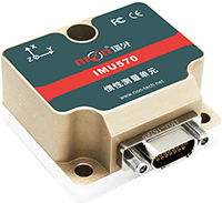
 Product Description
 Scope of application
 Parameter
 Dimensions
 Download
The IMU560 series is a GPS/INS integrated navigation system built by RION.the inertial measurement unit (IMU) is precision calibrated throughout the temperature range to meet performance requirements in different environments. The multi-data Kalman filter fusion algorithm is realized by a built-in navigation computer, and outputs real-time accurate carrier posture, heading information, three-dimensional position and velocity information, and various inertial device information. The appearance is exquisite, the structure is small, the installation is convenient, the use is flexible, and the operation is more stable and reliable.


| IMU560 | PARAMETER | UNIT | |
| Roll/pitch 1σ (dynamic) | 0.3 | ° | |
| HEADING POSITION ESTIMATION ACCURACY | Heading Accuracy 1σ | 0.3 ° (GPS effective) | ° |
| 0.5°(GPSunlock 5min) | ° | ||
| Pure Inertial Position Estimation Accuracy 1σ | <40m@1min(GPS unlock) | m@1min | |
| Output Frequency | 1~100 | Hz | |
| GYRO | Range | ±300 | °/s |
| Zero Bias Instability(Allan) | 10 | °/h | |
| Zero Bias Stability(10s Mean) | 15 | °/h | |
| Zero Bias Repeatability | 15 | °/h | |
| Nonlinear Error | <0.1% of FS | | |
| Scale Factor Nonlinearity1 | <0.02 | % | |
| Scale Factor Change ( 25 ° C) | ±0.3 | % | |
| Resolution | <0.01 | °/s | |
| Acceleration Sensitivity | <0.0028 | °/s/g,rms | |
| Angle Random Walk | <0.15 | °/√hr | |
| Noise Intensity | 0.014 | °/s/√hr | |
| Bandwidth | 100 | Hz | |
| ACCELEROMETER | Range | ±4 | g |
| Zero Bias Stability | 0.2 | mg | |
| Full Temperature ZeroBias | 1.7 | mg | |
| Scale FactorStability | <0.1 | % | |
| Resolution | 0.1 | mg | |
| Nonlinear2 | 0.1 | % | |
| Noise Intensity | 200 | ug/√hr | |
| Bandwidth | 100 | Hz | |
| MAGNETOMETER | Range | ±2 | Gauss |
| MAGNETIC AZIMUTH | Range | ±180 | ° |
| Accuracy | ±1.0 | ° | |
| Air pressure | Pressure range | 1000~120000 | |
| Barometric error | ±250 | Pascal | |
| STANDARD GPS PARAMETERS | Start Time | Cold start: 29s hot start: 1s | |
| Sensitivity | -166dBm | ||
| Speed | 0.05m/s | ||
| Azimuth Accuracy | 0.3°,P=50%@30m/s | ||
| level reckoned accuracy | 2m | ||
| ENVIRONMENTAL CHARACTERISTICS | Vibration Resistant | 10grms、10~1000Hz | |
| Impact Resistance | 100g@11ms、3 Axial Direction (Half Sinusoid) | ||
| Range Of Working Temp. | -40°C~+85°C | ||
| ELECTRICAL INTERFACE | InputCurrent | <100mA | |
| Input Voltage | 9-36V(Ripple 50mV) | ||
| Interface Type | J30J-9ZKP | ||
| COMPATIBLE SATELLITE MODE | GPS L1C/A, SBAS L1C/A, GLONASS L1OF, BEIDOU B1 | ||
| WEIGHT | ≤100g (Excluding cables) | ||

L48×W47×H31.1mm
L40×W39×H3.6mm
4 M4 screws
* Please contact the online sales engineer to obtain the product specification of Rion, or email sales@rion-tech.net to obtain it.


Copyright © RION TECHNOLOGY